
COLOMBIA (16 DEC – 26 DEC 2015)


It was only 2 days later that I managed to get GD as the Colombian customs were well known for its hassles. And if its not for Captain Ludwig (the boat captain) who did the clearance, it might took me longer than that. I went to DIAN office at 8 in the morning to sign the papers, then to the dock where the boat picked me and the others. We sailed for 10kms and waited for the aduana officers to come up on board to check our papers, bikes and passport. It took them more than an hour for the checking and they chose 3 bikes at random for a more detailed checking. Then the boat unload all the bikes. I had to fix my side mirrors under the blazing sun, and later rode 14kms to the old city to find an insurance shop. It cost me USD31 (paid with credit card only as they didnt accept cash) for a mandatory insurance which will be the first thing the police @ milItary check point officers will ask if u are being stopped.


Cusco was a nice historical town, but somehow I found it a bit too touristy. Its not a surprise though, as Cusco was the most popular place to book a tour to Machu Pichhu, a world heritage site, which lies on the mountain in the jungles. I took the cheaper tour which only provide return transportation from Cusco to Station Hidroelectrica for 75S. It was a long 7hrs journey along amazing route which almost reached the snow peak Andes, plus a stretch of very ugly and scary offroad. If u had seen 'Bolivian Death Road' video on youtube, thats how the road looked like. Most of the time, the narrow offroad can only allowed one vehicle to pass. Arriving Stn Hidroelectrica, one can choose either to take a train which will cost USD30 (one way) or walk for 10kms to reach Agua Calientes, the nearest little town to Machu Pichhu. My option was the latter. I had to walk on the rail gravels along the rail line. At this age, it was quite taxing for me to keep up with the youngsters pace, but I managed. Even I'm faster than half of them. It took me 2.15hrs to walk non stop for 10kms to reach AC. It was already sun down when I arrived here. I went straight to the information counter to purchase Machu Pichhu entrance ticket (S128 @USD40) and a one way bus ticket (USD12) or u can climb up 7kms to reach the ancient site. I chose to save my energy and just took the bus.


After an unforgettable 4D3N experience on the 'biker pirate' sail boat, sailing from Carti to San Blas Islands on Carribean Sea and Atlantic Ocean, I finally reached Cartagena, Colombia. The sailing was fun in the beginning when the boat went around amazingly beautiful San Blas islands, but once it hit the open sea of Atlantic Ocean, I got a terrible seasick and couldnt do nothing except just lie down. I was happy when I finally step down on the land of Colombia. I took a taxi to the hostel which was located 4kms away, and was charged USD20. It was a daylight robbery, but theres nothing I could do as I had lots of luggage with me and the bike was still on the boat.
While waiting for my bike, I took the opportunity to visit the old city of Cartagena. Honestly my backpacking skills had gone rusty and I tend to forget about the existense of free guided walking tour. It felt like ages ago since I joined one. Anyhow, after chatting with fellow backpackers at the hostel, I decided to join the walking tour which was fun and informative. Most importantly, no need to get lost in the small alleys and no need to find the info center for free maps. Cartagena old city was very nice and vibrant. I loved the colonial buildings and the flowers dangling from the balcony. The women in their colourful skirt really caught my eyes but its not easy to photograph them. The 'based on tip' tour lasted for almost 3 hours. The temp reached 35'C and I felt myself melting in the heat of the old city.


It was only 2 days later that I managed to get GD as the Colombian customs were well known for its hassles. And if its not for Captain Ludwig (the boat captain) who did the clearance, it might took me longer than that. I went to DIAN office at 8 in the morning to sign the papers, then to the dock where the boat picked me and the others. We sailed for 10kms and waited for the aduana officers to come up on board to check our papers, bikes and passport. It took them more than an hour for the checking and they chose 3 bikes at random for a more detailed checking. Then the boat unload all the bikes. I had to fix my side mirrors under the blazing sun, and later rode 14kms to the old city to find an insurance shop. It cost me USD31 (paid with credit card only as they didnt accept cash) for a mandatory insurance which will be the first thing the police @ milItary check point officers will ask if u are being stopped.
Exiting Cartagena wasnt difficult but it took almost 30mins due to traffic. I had never seen a city so full of public buses everywhere. They filled the double lanes city road and had no respect for motorcycles, so there wasnt enough space to zip in between the buses. I rode via route 90 - 25 on a single lane road which was sometimes pretty bumpy and sometimes good. Colombians driving attitude were similar to the Cambodians. They droved as they liked, so I need to open my eyes bigggg to hv a wide 180' view. There were lots of fruit stalls by the road side. Colombia must be a fruit heaven. Theres one time I saw locals selling colourful live birds. The birds were not caged but stood on a branch which the guys held out to the passing vehicles. They stood loyally and didnt fly away. That was sooo cute. I passed 9 military checkpoints and only once being stopped. However, upon seeing my GPS, the officer shake my hand and let me thru. After riding for 380kms in 6.15hrs with only 1 minute break to drink from my bottle, I reached the small town of Caucasia. Theres nothing interesting here so I just relaxed in my hotel room which was sponsored by Incolmotos Yamaha Moto, Colombia.

The next day, I rode 265kms on route 25. It was a very scenic yet stressful ride, at least half of the way. The okey (no potholes) but sunken road was narrow, winding and with steep inclines @ declines and tight hairpin bends. One really need patience to ride on this road as there were lots of trucks on both lanes. Everytime, there will be looongg line of vehicles with trucks taking the lead. It was very tiring to overtake them one by one, and once u are done, not even 1 min ahead, there will be another long line awaiting. Continously. Repeatedly. When the opposite coming truck taking a sharp bend, the driver will take side, meaning half of my lane was gone. So where do I go? Theres no shoulder lane here, and the edge of the road was pretty high too. The most dangerous thing was vehicles from both sides of the road tried to overtake trucks in front of them. Most of the time, they had no concern for motorbikes. So when this happened, I need to slow down or stopped completely by the road side to avoid accident. The winding and narrow road really test my patience. When patience gone, I nearly ended down the ravine....Few times. Nevertheless, the very green view was spectacular. I saw lots of horses and freesian cows gazing upon the sky.

Upon reaching Girar Dota, I was met by Jader and Ferney, reps from Yamaha Incolmotos. They took me to the hotel to rest, and at night, Ferney and his girlfriend took me to watch a final football match at a cafe, between Nacional (representing Antioquia) vs Junior (representing Barranquilla). This was a very important match, which was similar to our very own Malaysia Cup. The place I'm at now was in Antioquia state, so everyone here was cheering for Nacional. The result was Nacional team won by penalty. Everyone was so happy and celebrating. Singing, dancing, music, fire crackers, honking, drumming, horn blowing...you name it. To the Latinos, football is life...football is pride...FOOTBALL IS RELIGION.
Since couple of months back, Hong Leong Yamaha Motor (Msia) via Mr Hoo and Mr Lee had been contacting their counterpart in Colombia, Alejandro, and notify them about my ride. I received hospitality from Incolmotos Yamaha Colombia and was taken to their HQ and factory. GD was given a full check up, oil change and tires change. Not just that, I was also being taken for a visit at the huge factory. I watched the workers assemble bikes and visited the Communication Plaza which had a story about the history of Incolmotos, a display of all bikes they ever had and the most interesting part, Yamaha here also combined their motors and music division together. Their musical staff, Mateo entertained me with beautiful songs. I really had a good time here. Thank you Alejandro, Luis, Jader and the staff at customer service and technical division for the hospitality. Thanks too to Hong Leong Yamaha Motor for all the support and for sending the tires for GD all the way from Malaysia to Colombia. After everything was done, Luis took me to his house in Medellin city.


During my stay, Jader from Incolmotos Yamaha Colombia took me for a ride to Santa Fe, about 60kms fr Medellin. The road was good and winding all the way. Santa Fe, a cobble street old city was surrounded by beautiful mountains. We also went to the hanging bridge over Rio Cauca. Later, Jader took me for a metro cable ride over Medellin. I get to see the red brick buildings and houses which filled the mountains as far as eyes could see. It was indeed a lovely day spent.


After 2 nights in Medellin, I continued riding to Cali, which was 445kms away. It took me 8hrs with a short 10min break, along route 25. The road was a single lane steep and winding fr Medellin to La Pintada. The first 100kms took me 2.30hrs. Then it was a flat road with some uphills @ downhills occasionally and after Pereira, it was a good double lanes road. I passed along beautiful mountains and coffee plantations along Autopista Del Cafe and later, sugarcane fields all the way to Cali. Theres a massive traffic about 20kms to Cali due to an accident and I cant zip in between the trucks as there wasnt enough space. In the end, I rode on gravels next to the road as I was dead tired already and all I had in mind was to reach my hostel ASAP. Cali was the 3rd largest city in Colombia, and its the centre for salsa dance. I stayed 2 nights in Cali, during Christmas. I met Manuel, who happened to be a biker, and he brought me to his parents house for lunch.

On my last days in Colombia, I rode 501kms from Cali via route 25 to Ipiales. The road was 70% good but mostly single lane and winding. I saw lots of military presence along the way. These days, I'm not scared of them anymore. Rumours about them taking money from foreigners could be a thing of the past. I found them friendly actually.
The view was soooooo breathtaking all the way. Its sooo hard to keep my eyes on the road. The wind was strong too. I had to battle with the wind for 3 hours. I also saw some mountain villagers, mostly kids and the elderly stretching out their hands asking for money when I passed. They were so poor. Pity them. Some even blocked the road with a piece of rope. Theres one time a black couple blocked my way and I had no choice but to stop. They asked for money. I just smiled and said "losiento, no money". With a pat on the lady's back, I asked to be allowed to move on. Luckily they let me go. Finally, after riding 8.20hrs, I reached Ipiales. Its cold and I was really exhausted, but the ride was awesome and I felt great satisfaction. In my opinion, the route from Popayan - Pasto - Ipiales, were the most scenic road in Colombia.


ECUADOR (26 DEC – 30 DEC 2015)
It was raining on the morning of 26th Dec, and was very cold. I checked out from the hotel and before crossing the border into Ecuador, I took the opportunity to visit probably the most panoramic church in the world, Santurio Las Lajas. This beautiful church was about 8kms from Ipiales and the road to reach here was pretty steep and winding. I had to walk down approximately 400m which was ok, until the time to return, its uphill. I had not done any workout except for walking ever since I started my ride. Nevertheless, the church was beautiful and stunning and there were lots of visitors there as it was Saturday. I bumped into Bruce & Doug, my sailing mates on the 'pirate' boat. It was so nice to meet them again


After that, I rode to the border. Its easy to cross both country borders. It took me just 10mins to stamp my passport and cancelled the permisso on the Colombian side, and about 40mins on the Ecuadorian side. It could had been faster if not bcos there're many ppl today. For the first time in Latin American countries, I didnt have to pay to enter a new country.

As in Colombia, Ecuador was mountainous and beautiful as well. As yesterday, its hard to keep my eyes on the road. It was soooo green with some yellow flower fields which I'm not so sure what it was. I saw lots of sheeps and horses. The road on E35 was okey but there're some construction parts and its no fun to ride on winding downhill on gravels. I almost dropped the bike once. Theres one time I had to stop due to landslide. While waiting for the bulldozer to clear the road, more sands and rocks fall from above. It happened right in front of my eyes as I was just 10m away. That's scary. The landslide happened due to the strong wind which moved the rocks on top.

I rode 196kms and reached Otavalo, a small town but very popular with its outdoor market. It was quite difficult to find a guest house here as I didnt have any Ecuador map installed in my GPS, so I was going round and round. I found one finally, and didnt waste much time to explore the very interesting market where the Incas sold their merchandise. Inca guys're handsome :)

Navigating my way in Ecuador was not too difficult even though without the guidance from my GPS (except when entering towns), as signboards along the national highway were quite clear and the road was 90% good. Ecuador had tolls for motorbikes but its only 20¢ per toll. This country did not has its own currency, but using USD for trade @ business. Unlike its neighbouring Latin countries, I didnt see military presence here. It felt safe to ride here and the view was sooo gorgeous. Similar to in Msia, along my ride today, I could see many group of big bikes going for their weekend coffee ride.
I rode 320kms via route E35. Its winding, climbing and windy all the time. Theres one time when I'm about to day dream while enjoying the view, a sudden wind gust blew me and GD. In a split second we were pushed from slow lane to the fast lane. Phewww...Thank god theres no car on the fast lane at that time and I managed to control the bike. I had never experience such strong wind gust. It felt as if a bomb exploded right on my face. I finally reached Riobamba, the 3rd largest city in Ecuador after riding for 5.30 hours. Its very cold here as this city was surrounded with mountains.

The next day was a very beautiful but stressful ride to me. It started with a very nice, relaxing, pleasant and enjoyable ride. I purposely chose route 35 - 47 - 40 - 25, without knowing what to expect. After all, this was my adventure. Without knowing, this route happened to run parallel or above the famous Andes rail line which was an attraction for those who visited Riobamba. I'm glad I chose this route as the train didnt run everyday, so I still managed to see the same awesome view, but on my bike. It was sooo lovely and I stopped too many time for pics. Then the view changed to pre-desert with bushes (wind was strong here) and later mountains again. The difficulty when riding on this route was sign board were close to none, and since I'm not using my gps, I had to ask locals for direction. With my broken spanish, I survived. The rural road I chose was in ok condition (ok meaning not so many pot holes) and with very few traffic. Its cold and winding as usual bcos this country was mountainous.


After ascending a mountain, I thought I had entered the clouds bcos when climbing, I could almost reached the low clouds. In the beginning, visibility was 20m, then reduced to 10m, then 5m and at times, I couldnt see nothing. I was going at only 10 - 20kmh. The white road lines was my only guidance, but after a while, theres no more lines to follow (its Ecuador rural road). It was really scary when you had to descend or ascend without knowing where u r going, and I had to brave this for 35kms!!! To make matters worse, there was a road washed away that I had to cross and in the thick fog, I was chased by dogs for 3 times. At one time, 4 dogs chased me all at once!!!

I was very exhausted by the time I managed to get out from the thick fog zone. My earlier google map calculation was 306kms for todays ride, but I don't know how, when I thought there will be 30kms more to reach my destination, the sign board said that Machala was 120km more. Urghhhh!!! In the end, I reached Machala after riding 400kms in 9hrs and spent another hour trying to find a room suiting my budget. Its a looonggg day without eating anything since light breakfast this morning, and believe it or not, the last time I pee was 12 hours ago at my hotel in Riobamba.
PERU (30 DEC – 18 JAN 2016)
Heyyy, welcome to Peru lah :)


Its quite a straight forward border crossing from Ecuador to Peru, except it took me about 2.30hrs for both borders as there were many people today. To cancel Ecuador permisso, I had to go to CEBAF building which was 2kms fr the border. There was no immigration office on the Ecuador side though, even after the bridge which had the Welcome to Peru sign. I was worried as I had not stamp out my passport yet. Apparently both Ecuador and Peru immigration counter was located side by side in a building about 3kms from the Peru welcome sign, and the customs was on the next building. Mandatory insurance was USD35, then GD rolled its wheels on Peru PanAm Norte route 25 highway. After withdrawing some Peruvian Soles at Tumbes, the border town (no money changer at the border), I started to feel as if I'm in another planet. Gone were the Ecuadorian green mountain views but was replaced with barren desert hills. Wind was strong but not so bad and the road was okey. Whats not so okey were the locals driving attitude. I reached Mancora after riding for 200kms and since it was peak season as new year was approaching, rooms were expensive. I found a very nice place to pitch my tent which faced the Pacific Ocean. I fall in love with the place and decided to stay there for 2 nights. My friend, Tim Charman from Canada, whom I met last time in Baja Cactus, also arrived this town today and I shared my location with him. He arrived not long after and pitched his tent next to mine. It was very good to see him again. We went around the town and even to the wet market to shop for fresh seafood which was very cheap here. It was good to enjoy delicious seafood after eating the same menu everyday for months.

After 2 nights in Mancora, and as I'm getting ready to pack my tent, I heard Tim calling my name. He told me that he lost his wallet while celebrating New Year at the beach last night. I didnt go to the beach with him, where the locals were celebrating, but prefer to enjoy the fireworks from my campsite. Tim told me that there were about 10 000 people on the beach and he felt a push from behind. The next thing he knew, his wallet was gone. His ATM card, credit card and driving license which were in the wallet were gone as well. Thank god he still had his passport. This news came to me like a thunderstorm. I had been adapting well in Latin countries and kinda forget about being careful sometimes. I felt so sorry for Tim and lend him some money before saying goodbye, with a promise to meet again.
I rode 430kms on Pan Am Highway from Mancora to Pimentel in 6 hours. The road was 80% good but the wind? Perghhh!!! The straight looonggg road crossed the desert for miles. And the desert? Its flat and empty as far as the eyes could reach. No tree, building or whatsoever except for the electric posts. I had to fight the side wind for approx 200kms. From Pimentel, again I had to fight strong head & side wind all the way for 400kms. There were times that vehicles from the opposite direction gave me high beam. I supposed from a distance, they could see my bike swayed left and right. I noticed GD consumed more fuel than normal due to the strong wind. Theres nothing to view here except for dunes and barren rocky or sandy mountains at certain places. Anyway, its kinda cool to see the fine desert sands shifting places as it crossed fr the right to the left side of the road when being blown away by the wind.


Since Ecuador, I had stopped using my GPS. Previously, I didnt have Ecuador map in the GPS, but now, the GPS's touch screen frozed, so its unusable anymore. Since I didnt have a paper map with me, its back to old school navgation. I had to be alert on the signboards, or look at the sun to determine my direction, or asked locals. My Spanish was far from able to have a decent conversation, but to ask for direction, I think I'm getting better from day to day. However, tomorrow, its going to be a challenge to ride without the help from a GPS, as I'm entering Lima, the capital city, which the driving attitude of the locals were said to be worse than Delhi.
The road to Lima took me 475kms in 9 hours. The view was very spectacular along the way, but again, I had to beat crazy wind (I had sore arms and neck by now). Not just that, I also had to stop by the road side countless of times to check for direction as my GPS was not functioning. I had to face crazy drivers in Lima too, and almost run down twice by a white Fiat ALL 275 who drove like a maniac. I was also being stopped by traffic police bcos taking the road not allowed for bikes (luckily he didnt gave me a ticket). Finally, I made it into Lima, the 3rd largest city in Americas with 10 million population. I was soooo exhausted by the time I reached the hostel where I want to stay.


I stayed 5 nights in Lima and managed to visit the Malaysian Embassy there. I was almost into tears when I saw Malaysian flag and Malaysian emblem at the embassy. I met the Ambassador, Dato Ayauf Bachi, and the staff, En Adham, Pn Hanis and Pn Sharmini. Dato chatted with me for 1.30hrs despite his busy schedule. En Adham and Pn Hanis invited me to stay at their houses. Pn Hanis's husband, En Wan helped me a lot during my stay in Lima by driving me in and out everyday to settle my matters – sending my GPS for repair and to sort out my Bolivian visa. A friend, Carlos, introduced me to Alejandro who managed to fix my GPS. I was soooo relieved. However, getting Bolivian visa was a pain in the ass. I had to go to Bolivian embassy 6 times before I finally got my visa sticker on my passport. I would had surrendered if not for En Wan's patience. The last 2 nights, I stayed with En Adham and his wife, Pn Maryam. They were very kind to me. Another staff of the Malaysian Embassy, Miss Sharmini took me out for dinner on my last night, while En Wan took the trouble to lead my way to exit the city of Lima to head south. I really am so grateful to all of them for their kindness.


After exiting Lima, I rode 335kms on PanAm Sur (South) to Huacachina. The speciality of this place were the amazing sand dunes. However, due to my lack of fund, I didnt take any 4WD tour to visit the dunes. I only view them by the road side.

The next day, I rode to Nazca. Again it was desert all the way but with some green fields views at Palpa. I dropped by at Geoglifos de Palpa to view some lines by the Incas. I had to climb a tower for better viewing. Only 3 geoglyphs @ pics can be seen at this place.
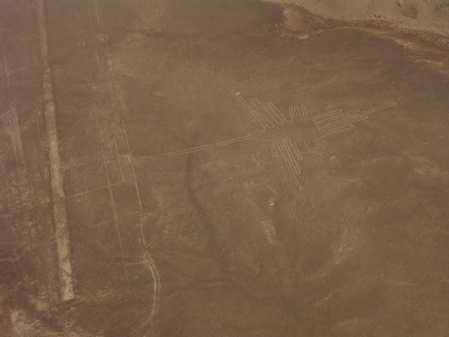
Upon arrival to Nazca, I headed straight to Nazca Airport, to check on tour prices for flight over Nazca Lines. Even though, I'm on a budget, this tour is not to be missed. I had been wanting to see the Nazca Lines ever since I was 15 years old!!! The price to see this lines from the air was approx USD85 + USD10 (airport tax). Nazca Lines was a huge representations of geometric patterns, animals, humans figures and thousands of perfectly straight lines that go on for kilometers. They were created by removing surface stones, revealing the lighter-colored soil below. They're unquestionably ancient (dating back 1400-2200 years), and remarkably precise (with straight lines and clean curves). The images were huge that they were best appreciated from the air, a fact which has led to speculation that the ancient Inca people either had access to hot air balloons or alien helpers. Until today, no academics or scientist can confirm who actually made the lines or whats the significance of it.


The flight over Nazca Lines was a quick 30mins flight, too quick to truly appreciate the lines actually. I got may be 10 seconds for each figure before the next one. It's a bumpy fast ride in the small 6 persons (including 2 pilots) aircraft. Its hard to get a good picture due to the bumpy ride. I almost throw out and somehow relieved when the flight was done. Anyway, the lines themselves were amazing. To be able to see them for real from the air and to finally achieved one of my childhood dreams after dreaming about them for 33 years, was too good to be true. It left me with one kind of self satisfaction and wonders, and unsolved mystery of how the ancient Incas made them. I would like to thank Bob Robert Shannon for sponsoring me this tour and for making my dream came true.
I stayed 2 nights in Nazca, and after that made my way to Cusco via route 3S. I purposely did it slowly as to acclimatize with the altitude as the road to Cusco climbed high mountain passes. It took me 3 days to arrive Cusco with stopovers at Puquio and Abancay. It was a very enjoyable and scenic ride, even though its quite windy at certain places. The first mountain pass I climbed was at 4300m, and I felt dizziness, but not too bad. The view was soooo spectacular and changed with the altitude, that I felt as if I'm looking at an artists masterpiece. The road to Abancay ran parralel with the greenish blue Rio Pachachaca which winded its way along the many gorges of the Andes Mountains. It was sooo beautiful. I also saw lots of sheeps. Ohh...and vicunas too!!! Tons of them, but they were too shy to pose for my cam. I saw few high altitude lakes too, but too bad its a cloudy day so the supposedly blue lakes didnt appear blue due to the lack of sunlight. It was freezing and winding almost all the way.


The stretch from Abancay to Cusco, even though paved, must not be taken lightly as the climb was from 2500m (at Abancay) to 4000m (the highest point). Also, there were lots of debris on the road due to landslides. View of the Andes was gorgeous. Beautiful and colourful rock formation can be seen along the way. For the first time since I started GDR, today I saw snow peak mountains. It seemed so near and I felt joy and brrrrrr...Finally, after riding 716kms in 3 days, I arrived Cusco.


Machu Pichhu needs no description. Its everyones dream place. You should visit it at least once in your life time. As for me, I had dreamt to be here since I was a teenager. Its far, yes...and its challenging to reach here especially when riding alone. But the satisfaction, only god knows.
To be here was somehow unbelievable. Its hard to describe my feelings. The first sight of MP definitely was a sight to remember all yr life. Its all ooohhss and ahhhsss. It was sooo impressive. It left me with wonders...as how I wondered upon laying my eyes on the pyramids in Egypt, Al Khazneh in Petra, and many other ancient sites. How did the ancient Incas built this city on the mountains without modern tools and technologies? How did they carry the stones up the mountains? How? How? How? Too many questions which I didnt get the answer as yet.


I spent 4 hours to explore the historical site, until the Inca Bridge and as I'm running late, I had to take the bus again (USD12) to AC. Then, I took the expensive 50 minutes slow train (USD30) as I didnt have the energy to walk the 10kms anymore. All in all, total cost for me to see my childhood dream place was USD137 (inclusive a cheap bed at AC for USD15). Yes, its expensive, but its the wonders of the world, and Machu Pichhu worth every single $ which I spent. My special thanks to sis Puteri Juliana for her generous contribution and big support for me to fulfill my childhood dream to visit this special place and to continue with my ride.
My last destination in Peru was Puno. Its a chilly wet ride almost all the way. When I reached Juliaca, the offroad was sooo bad with lots of pot holes filled with rain water and there was a weekend market going on. It was a very tense moment as I had to squeeze in between the many ppl, the stalls, and the road was muddy and slippery. Thank god I didnt drop GD. When I was climbing up a mountain to reach Puno, there was snow on the road!! I reached the town after riding for 420kms via route 3S with highest elevation at 4355m.


No comments:
Post a Comment